Communications breakdown: keeping teams connected during disasters

Amy Gallagher speaks with New Jersey and Pennsylvania National Guard forces on keeping the critical communications infrastructure in the wake of Hurricane Ida
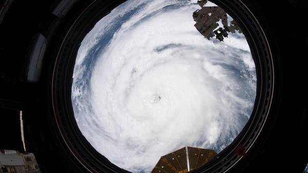
Hurricane Ida made landfall around 12:00 on 29 August – the 10th anniversary of Hurricane Katrina – near Port Fourchon, Los Angeles. As a Category-4 storm, Ida struck with sustained winds of 150mph, making it one of the most life-threatening storms to surge along Los Angeles, Michigan, and Alabama, before churning inland and upward throughout the Northeastern US. Ida caused historic and devastating flash flooding and threats to public health, safety, and infrastructure.
The multiple federal and state agencies dependent on communications during disasters do so through the critical infrastructure (CI). It is a complex and interconnected system, and its secure functionality is relied upon when events such as Hurricane Ida’s wrath strike and risk loss of electricity, transportation, water, healthcare and communications.
Those who activate such communications are the soldiers and airmen assigned to the National Guard Bureau who co-ordinated Hurricane Ida response efforts from the National Guard Coordination Center in Arlington, VA, including those within the New Jersey Army National Guard (NJARNG) who ensured the transfer of communications and technology to essential resources and assets. One CI system utilized within the NJARNG during Ida is the Emergency Management Mapping and Information Tracking (EMMIT).
“When the New Jersey National Guard receives a request for support from a civilian agency, the primary means of contact is a web-based application,” explained US Army Major Justin Moore, Operations Officer of the NJARNG Joint Operations Center. “We’re also on the phone with the Trenton-based Regional Operation Intelligence Center, which facilitates backup power generators. In the event of a total blackout, we send a ‘runner’ to relay messages. Fortunately, it hasn’t gotten to that point.
“We can communicate with our airframes over UHF and VHF, which can also speak on the same band as the New Jersey State Police.”
SHOUT it out
According to Colonel Frank Montgomery, Director of Military Support, Pennsylvania National Guard, federal and state agencies have multiple sources of communications options during disaster events at the severity of Hurricane Ida: “The Pennsylvania National Guard has several methods of communication available in the event of an unanticipated disaster to include phone, email, statewide radio, and even other methods such as high-frequency and some other satellite-based platforms such as ‘nano-shouts’.”
The ‘nano-shout’ – slang for NAL Research’s SHOUT Nano – is a handheld global, two-way satellite messaging and personal tracking device that provides location information determined by a GPS receiver, two-way inbound and outbound status, text messaging, and emergency and alert notifications. The SHOUT Nano has an internal rechargeable Li-Ion battery, a high-resolution LCD screen, a 011 alert button for emergency situations, and is small enough for easy concealment.
Redundancy during a crisis can also be a powerful strategy knowing oftentimes that information is not received or misunderstood, notably when communicating with multiple sources throughout the region. Montgomery stated: “We have redundant power sources throughout the commonwealth at our facilities and we also work with our commercial partners to ensure we have priority access to cellular phone and email as part of the first responder team.”
State resources include the State-branch of the Federal Emergency Management Agency (FEMA) such as the Pennsylvania Emergency Management Agency (PEMA). Montgomery continued: “We co-ordinate and exercise these communications plans with the PEMA throughout the year, not just during emergencies.”

Smith Myers details the effectiveness of the ARTEMIS mobile phone location detection system in airborne SAR environments - SPONSORED CONTENT
How effective is ARTEMIS in low-to-no mobile coverage areas?
Artemis works extremely well in these areas, despite typically being the most difficult for the SAR operator, as they will receive little assistance from the network operator as to the general area to search. In areas of no coverage, due to remoteness or terrain, or even a disaster situation, the mobile phone(s) will be looking for the ARTEMIS signal. In these conditions it is possible to see ranges of 35km being achieved, which could give a search path 70km wide.
What informed the decision to make the ARTEMIS user interface browser-based?
All Smith Myers products are designed with a browser-based user interface, this enables trouble-free integration with any other equipment. All you need for an onboard UI is a screen running a browser and a LAN connection. If the system must be operated remotely, as per a UAS installation, then any IP link from the aircraft to the ground can be used to connect the ground-based browser to gain full access to ARTEMIS features. The interfaces are industry standard and used across the world. Gone are the days of weird camera signals or strange serial busses with proprietary signalling.
Can you tell us more about the distance estimation algorithms that enable ARTEMIS to operate without specialist antenna arrays?
Smith Myers have developed several distance estimation algorithms which don’t use signal strength, or a dedicated direction-finding antenna array, but use the cellular protocol to get very accurate distance measurements. This is achieved through the Smith Myers-designed Software Defined Radio system from a clean sheet specifically for the task. Continuously calculating the distance to the phone, coupled with the aircraft’s GPS, permits ARTEMIS to effectively perform continuous auto triangulation, producing a Lat and Long fix, to display on the embedded mapping or for use by the mission system which in turn can cue the EO/IR camera to look at the location. This now opens up the possibilities of missions in low light or IMC conditions to be conducted with a high degree of a rapid and positive outcome.
Find out more about ARTEMIS - Cellular Geolocation System and how it is optimized for use in SAR
Futureproofing communications technology
As in all technology, improvements and advancements in communications are an ever-present need. But the reality with disaster communications is in sourcing the right options that align with the operator’s budget. “The Pennsylvania National Guard is currently fielding new radios that afford state-wide coverage and complete inter-agency connectivity,” explained Montgomery. “These new radios will replace older model 800mhz and will allow our personnel the ability to reach out to all of our interagency partners, with some prior co-ordination regarding frequencies. We also use other internet-based communication methods to ensure we are sending and receiving the latest information to our inter-agency counterparts.”
Montgomery added that the Pennsylvania National Guard ‘also has several satellite platforms that provide connectivity that are commercial and tailored for domestic operations, in addition to tactical communications that aren’t used very frequently during domestic operations’.
Elsewhere in Pennsylvania, Lieutenant Colonel Randy Lutz, Commander of the Eastern Army National Guard Aviation Training Site, shared how his region utilizes communications assets through natural disasters like Ida: “The federal and state agencies employ a PACE plan (Primary, Alternate, Contingency, Emergency) communications plan to support effective communication during federal and state domestic operations and contingency operations. Advances in technology deliver adaptive capabilities, access to interact with emergency management dashboards for situational awareness, planning, use of digital and over the horizon communications, and asset tracking.”
With respect to future communications systems needed, Lutz said, “The federal and state agencies integrate a variety of communications platforms and diverse capabilities, including analog, digital, encrypted, employed via network, ground, air and geospatial means to manage disaster and emergency response.”

October 2021
Issue
- The demand for automation reveals its shortcomings meeting the human factor
- How virtual and augmented reality meets the needs of SAR/HEMS training
- Keeping critical communications infrastructure live during Hurricane Ida
- How logistics is the critical challenge of neonatal air transport
- The latest SAR equipment that pairs innovation with affordability
- Interview with Rob Pennel about the EASA South East Asia Partnership Program
- And more
Amy Gallagher
Amy Gallagher is an internationally published journalist covering aviation, rescue, medical and military topics, including evidence-based research articles. As a journalist by education and certified English instructor, Amy has worked in both agency and corporate communications, providing educational and promotional writing and training services through her agency, ARMcomm Writing & Training, www.ARMcomm.net.

