Automatic target detection for SAR support

Flysight discusses the use of technology to enhance the ability of SAR teams to find their victims faster
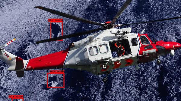
One of the biggest problems that search and rescue (SAR) teams have is identifying a target in difficult terrain. Whether that’s out in an open space or an urban environment, the longer it takes to locate a target, the lower their chances of survival become. This problem is compounded for aerial support teams when the distinction between an individual and their surrounding terrain can become almost nonexistent. The human eye is exceptional at spotting detail, but to help SAR teams become more effective, technology has the edge, especially automatic target detection (ATD) systems.
Using ATD from an airborne platform has a host of advantages. Primarily, the information is uploaded to the video stream in real time, allowing the technology to identify a target and instantly relay the location to the operator. Because ATD technology has been calibrated to identify specific objects (such as a vehicle or pedestrian), it also filters out any background ‘noise’ that may pollute the identification process far more effectively than a human can. For example, if a victim is wearing lightcoloured clothing in an environment with a lot of similarly coloured detritus, ATD technology will be able to extrapolate the individual from their surroundings far more quickly. While it may be difficult for a human operator to identify the individual amongst the background noise, ATD finds it easy to do so, minimizing missed sightings even from the air.
One of the critical components of ATD is target georeferencing. Once the software identifies a target, it immediately allocates a georeferencing point, which can be transferred to SAR groups on the ground. Using this technology, the aerial team can coordinate the ground response units to zone in on the target more effectively. This reduces response time which, in a life-or-death situation, is vital.
Another aspect of SAR that automatic target recognition can assist with is user fatigue. During long-duration search and rescue operations, user fatigue can dramatically reduce the ability of a human operator to effectively scan search areas continuously. A study by Cornell University found that the difference between the human eye detecting a target and an ATD system was a matter of a few seconds initially. But over a prolonged period, the accuracy of the human operator waivered, whereas the ATD system consistently identified and pinpointed targets in under 10 seconds. The use of synthetic data generation and augmentation also renders the information not only more accessible but also exceptionally accurate, regardless of the amount of time spent in the air. By transposing it onto streaming video, a real-time search map can be produced that has fewer instances of false-positive sightings, which can be an issue with human operators.
With open spaces such as mountainsides, the issue facing SAR teams is the sheer expanse that needs to be covered. However, for SAR in an urban environment, the problems are more focused on the number of potential targets that could confuse any ATD system. However, in recent years detection tools have become more refined and more capable of dealing with multiple small targets in close proximity to one another. Systems such as OPENSIGHT can identify a higher number of small targets and georeference each one instantly. This allows a trained operator to focus on targets of interest and eliminate background noise that has no relevance to the operation. In an urban SAR operation, this is particularly important. If the target is known, a set of parameters can be programmed into the system that ‘fine-tunes’ the target identification process even further.
Systems such as OPENSIGHT can identify a higher number of small targets and georeference each one instantly
In SAR, time is of the essence. The longer it takes to find a target, the greater the chance of serious physical harm or even death. ATD enhances the capabilities of airborne SAR units and minimizes the possibility of human error. It reduces search time by capturing single or even multiple targets in any terrain. Even hard-to-spot targets can be more easily identified, and by the use of target georeferencing, their exact location can then be relayed to ground teams. The result is greater success in search and rescue operations, regardless of the terrain.

November 2022
Issue
Cockpit automation heightens safety, the move by air medical providers to longer-range jets, the standardization of infectious disease patient transfers, and electronic communication in the Mediterranean Sea helping to aid refugee rescues
FlySight Team
FlySight S.r.l. (A single member Company) is the Defense and Security subsidiary company of Flyby Group, a satellite remote sensing solutions company.
FlySight team offers integrated solutions of data exploitation, image processing, avionic data/sensors fusion. Our products are mainly dedicated to the exploitation of data captured by many sensors typeand our solutions are intended both for the on-ground as well as for the on-board segments.
Through itsexperience in C4ISR (Command, Control, Communications, Computers, Intelligence, Surveillance and Reconnaissance), FlySight offers innovative software development and geospatial application technology programs (GIS) customized for the best results.
Our staff can apply the right COTS for your specific mission.
The instruments and products developed for this sector can find application as dual use tools also in many civil fields like Environmental Monitoring, Oil & Gas, Precision Farming and Maritime/Coastal Planning.
